Key Features
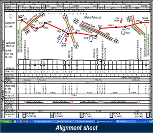
A simple Total Station file in CSV text file format is sufficient to generate the basic Alignment sheet, reports like Control Points Chainage, Bearing and Deflection angle.
Additional data like Population Density, Soil Resistivity/Soil Investigation, and Land Details can be entered into the database through a unique User Interface, which allows the user to edit directly or load data through a CSV file.
Generate Crossing Drawings, Drawings with Soil Investigation/Soil Resistivity details.
Ready availability of data pertaining to the Crossing or the Photograph of the crossing.
Map Data utility to check the accuracy of survey data at site.
Generate Soil Investigation details as either a Drawing or a Report.
Option to change, add or delete the Feature Codes (used during survey, data captured by Total Stations), so as to accommodate a variety of instruments and site details.
Multi-user facility to view generated drawings from a central site.
Secured Data Access.
Product is highly scalable to meet additional customization as per client’s requirement.
Case Study
Client : Gas Transportation Infrastructure & Co. Ltd (GTIL)
Earlier constraint: GTIL, a part of Reliance Industries Ltd. (RIL) a premier industrial group in India, had inadequate IT enabled data process and monitoring system for their cross-country pipelines
SECON’s role: SECON, the primary vendor for GTIL’s Engineering Consultancy, fulfilled the high quality and data accuracy requirements of GTIL by developing SASG for automatic generation of alignment sheets.
Implementation: SECON installed SASG application in all the zonal offices of GTIL for efficient data management. User-friendly tools were developed to facilitate automatic generation of engineering reports like Alignment sheets, Crossing reports, Survey reports, etc., using centralized database.
Results: Common platform was built to achieve quality and uniformity of data delivered by various contractors in the generation of engineering reports/drawings, resulting in substantial reduction of supervisory staff.
Testimonial
“SECON’s Pipeline management modules for generating crossing drawings, bore logs, reports, etc., ensures mapping and capturing with much higher speed and excellent repeatability compared to conventional methods. Updating and retrieval of data and information is greatly simplified. Being GIS compatible, the product has the capability for a seamless integration with other available pipeline application to perform “End-to-End” functions for Pipeline facility in all phase of its life cycle, viz., Concept to Commissioning.
Senior Executive Officer, Gas Transportation Infrastructure & Co. Ltd., Mumbai
Major Projects
- Reliance Pipeline - 5000 Km
- IOCL-PHDPL (Paradip - Haldia - Durgapur) - 330 Km
- OIL India Limited P.O.Duliajan, Assam - 445 Km
- TATA-NJPL Noamundi to Jamshedpur Pipeline - 107 Km
- HPCL-RKPL (Rewari to Kanpur Pipeline) - 441 Km
- ONGC-JBPL (Jorhat to Borholla Pipeline) - 67 Km
- HPCL-MHBPL (Mangalore - Hassan - Bangalore) - 550 Km
- GSPL - Dowlaiswaram - Tallarevu Water Pipeline - 70 Km
- GAIL - Bhajera - Agra - Ferozabad Pipeline - 78 Km
- Dighe - Loni - Talegaon Pipeline - 150 Km
- Rewari - Kanpur Pipeline - 430 Km
- GSPL (Tana to Amreli Spurline) - 75 Km
- ONGC Phase-I (93 Km) & Phase-II (273 Km)
- Tata Steel - 130 Km
- GSPL_JBPL - 400 Km
- ISPAT_Bailadilu - Vishakapatnam Pipeline - 415 Km
- GSPL - Jodhpur Spur Line - 152 Km
- HPCL - Mittal Pipeline - 1014 Km
- GAIL (Bawana-Nangal) - 525 Km
- HMPL (Mundra to Bathinda) - 235 Km
- GAIL - Gauna to Ludhiana Mainline & 2 Spur lines - 513 Km
- GSPCL (Anjar to Palanpur Pipeline Project) - 276 Km
- GSPL (Palanpur - Jaipur - Bhiwari Pipeline) - 100 Km
- GSPCL (Kakinada to Ahmedabad) - 1300 Km
- Dabhol-Pune Pipeline Network & Mainline - 150 Km
- Tehran Jonoob-Jaihind Consortium - 150 Km
- GAIL (HVJ Pipeline) - 550 Km
- GSPCL (Hyderabad–Bhopal) - 757 Km
- CAIRN (Viramgam to Salaya) - 260 Km
- GAIL - HVJ & JLPL Pipeline & BG Pipeline - 1000 Km
- OIL INDIA - 250 Km
- GSPCL - 214 Km
- ONGC-460 Km (Barmer to Mundra)
- ONGC-272 Km (Geleki, Lakwa & Lakmania Fields-Phase II)
- GSPCL (Kakinada to Amedabad) - 1300 Km
