Scope of Work
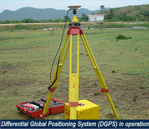
SECON’s scope of work generally includes Control Survey, Monumenting, Frame work for Planimetric and height control, using Differential Global Positioning Systems(DGPS), Total Stations and Automatic Levels.

We conduct Property line survey, validation, Topographical and Precision engineering survey and setting out for land development works Field data and sections are plotted, digitized and Digital Terrain Model (DTM) output is supplied to the client together with a survey report
Hydrographic survey work includes Control survey, Sub-bottom profiling, related investigations by using Differential Global Positioning System (DGPS), Eco-sounders and Lead Lining, depending on site conditions
- Control survey, monumentation for planimetric and height control
- Rapid updation and large scale surveys using satellite imagery and aerial photographs
- 3D contouring, terrain modeling and deformation study
- Property line survey, validation for large infrastructure projects
- Alignment surveys for utilities
- High precision engineering survey and setting out
- Sub bottom profiling and related investigations
- Route optimisation of navigation channels
- Ocean engineering, harmonic analysis for tides, current and wave studies
Major Projects
LIBYA PROJECT
Other Domestic Projects
- Hydrographic and Geotechnical Investigation for Rivers and Liasoning services for Obtaining Environmental Clearances for Mehsana-Bhatinda Pipeline for GSPL India Gasnet Limited,
- Hydrological Study, Engineering Survey, Investigation, Preliminary Design of intake system and Raw Water Pipeline, preparation of detail design report & preparation of detailed tender documents for Shree Uttam Steel & Power Ltd
- Topographical Survey for a Site near Vizag
- Provision of Preliminary Survey For Acquisition of Land at Site-K near Bhopal
- Detail Topographical Survey of certain areas at site - Ponta Sahib
- Topographical Survey of proposed land of ATR at Chitradurga.
- Preliminary Planning, Survey, Site selection & Engg. report for Knowledge City, Morena Project for ESSL Infra Projects
- National Dairy Development Board, Bangalore 95 - Contour Survey to the land for Tumkur Dairy and Topographic Survey of Hosakote Chilling Centre
- Topographical Survey works for Pata Complex for Gail (India) Limited.
- Topographical Survey for the Proposed Express Terminal.
- Combined cycle power plant, Kawas, Surat - (1,400 acres)
- Refinery and township area, Bina (M. P. )
- Chemical plant site, Mangalore
- Devanahalli international airport, L&T and Hochtif - (4,200 acres)
- Macro level survey, topographical and engineering surveys and related investigations - (4,300 acres)
- Development project sites at Hyderabad, Karnataka, Nasik and Orissa - (6,000 acres)
- Strategic crude oil storage site, Mangalore - (258 acres)
- LNG tank area, Dabhol - (232 acres)
- Topographical survey for Airport at Hassan, Karnataka
- 330 MW Power Plant, Bhander Dist. Gwalior - (247 acres)
- HLL Premises, Brookfield, Bangalore - (26 acres)
- Deogarh West Coast refinery and Vizag Lova Gardens – (2,400 acres)
- Water shed project, Berambadi – (1,115 acres)
- Major units of steel plant & raw water reservoir, 2 x 250 MW Power Plant, Toranagallu, including setting out work and site supervision – (500 acres)
- Post construction survey and preparation of As-Built drawings, IT Park, Bangalore
- High precision control survey for 2.5 Km long fly over Sirsi Circle, Bangalore
- Township survey and related investigation for peripheral roads – (300 acres)
- Engineering and road alignment survey – (5,000 acres)
- Dolphin Hill Range township and approach road - (226 acres)
- Integrated steel plant, Tadipatri
- SNC Lavalin Inc., 1100, Rene-Levesque Blvd., W., Montreal Canada.
- Transmission line survey for upgradation of Kerala Electricity Board – (55Km)
- Calicut airport – (15 acres)
- Transmission line survey for upgradation of Kerala Electricity Board – 55 km
- Mobilization & Demobilization of Equipments, Desktop study of Diversion route
- Topographical Survey and Index Mapping for Mundra Port.
- Collecting and Compiling existing industrial unit details related to Narol Industrial estate
- Topographical Survey for well no. 6 & 7 and School building near GSPL – Niko Gas gathering station
- Topographical survey for the maps taking out grid levels at 10m intervals and marking countours at 0.25.
- Providing assistance for acquiring 4 acres land at Beach Park.
- Provision of Topographical Survey for Technical Facilities at Hosangabad
