Key Features
Easy retrieval of information related to 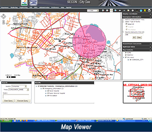
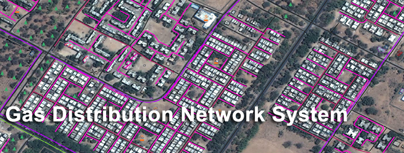
- Detailed map features, Roads & existing utility networks, As-Built details
- Existing & Potential Consumers
- Emergency assisting centers/locations/information
Links to :
- Billing information & Consumer information
- Customized Query & report generation for
- Gas usage statistics and Maintenance statistics, etc
Benefits
- Integrated application with up-to-date information – customer info, engineering info, document
management, MIS reports, risk modeling - Application is designed to for data capture efficiency, manage regulatory & internal HSE process
compliance - Valuable Decision Support System for planning and emergency response
- Application can be an effective marketing tool to understand consumer preferences and design
innovative products - Web / Email integration for corporate & field staff
- Improved maintenance response system for carrying out field activities
Major Projects
City Gas Projects
- Procurement and Processing of High Resolution Satellite Images, establishment of Ground Control using DGPS, Preparation of GIS Base Map, GIS Database development and Development of Web based solution Pipeline Information Management System to manage City Gas distribution Network for 10 cities across Gujarat.
- Procurement and Processing of High Resolution Satellite Images, establishment of Ground Control using DGPS, Preparation of GIS Base Map, GIS database development and Development of Web based solution Pipeline Information Management System to manage City Gas distribution Network for 02 cities across Gujarat.
- Preparation of up-to-date GIS Base Map using High Resolution Satellite Image (0.6 m) and Development of Web based GIS Application / Database for planning City Gas Distribution Network for Bhavnagar & Kachchh Districts in Gujarat
- Procurement of Satellite Image, Processing of Satellite Imagery, Preparation of GIS Base Map and Development of Web based GIS Application / Database using Satellite Image to Support Viewing of Gas Network Details, other Utility Networks, Consumer Details, Emergency Assisting Details, Engineering, HSE, O&M, Marketing and Document Management System, etc for Mehsana, Sabarkantha & Gandhinagar Districts in the state of Gujarat
- Route Survey and Allied Works for City Gas Distribution project at Bengaluru for GAIL Gas Limited, Noida