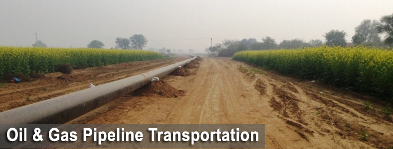
Scope of Work
One of SECON strengths is to provide services for the entire lifecycle of a Pipeline Project.
This includes Feasibility Study, Alignment Survey, Soil Investigation, Cadastral Survey, Right of Use (ROU) Acquisition as per Government Act, Statutory Clearances, Environmental Impact Assessment and Management (EIA/EMP), Social Impact and Rehabilitation Assessment (RA), Disaster Management studies including Environmental Clearances and assistance during construction/laying of pipeline.
Reconnaissance and Route Optimization using Satellite Images/ Base Map
Desktop study of maps / satellite imagery and identification of alternate pipeline corridors and optimization of best alternative.
Reconnaissance survey and establishment of flag control points at definable and major crossing locations
Assessment of terrain, geology, soil strata (visual), land use, forest area, land cost, weather, administrative jurisdiction and related information
Centerline and Detailed Route Survey
- Establishment of trench centerline
- Staking and survey measurements for angles, distances and ground profile
- Preparation of strip plan, alignment, and crossing drawings
- Collection of Meteorological data, population density, utility and administrative
jurisdiction
Soil Stratification and Resistivity Survey
- Stratification survey of soil / rock along pipeline by auger boring at specified intervals upto 3m depth and visual engineering classification
- Auger boring at major crossing locations upto 5m depth and testing of soil samples in a laboratory.
- Comprehensive corrosion survey, comprising resistivity survey, physical and chemical analysis of soil and water samples
Geotechnical, Hydrographic and Hydrological Investigations for HDD Crossing
- Deep boring for major river / creek crossings both in bed and at tanks
- Hydrological and hydrographic investigations for crossing locations (water table, aquifer studies, flow pattern, high flood level, bathymetry of river and sea bed, silt pattern, scour depth, sub-bottom profiling)
- Testing of soil samples at laboratory
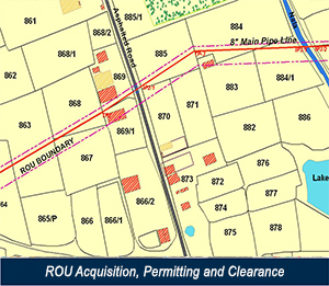
ROU Acquisition, Permitting and Clearance
- Cadastral survey and land information, ownership details, validation and data generation for ROU acquisition under the Pipeline Act
- Data management system for property inventory, evaluation of land, crops, and fertility loss for land compensation
- Assistance to Competent Authority (CA) for 3(1), 6(1) notification, serving of notices, recording of interest, payment of compensation
- Assistance in site selection and evaluation for stations and other facilities.
- Permitting and clearance from various statutory authorities, road, rail lines, foreign pipelines, underground and over-ground utilities, forest, and defense lands
EIA and EMP Studies
- Extensive data collection and analysis
- Socio-economic and environmental impact studies
- Pollution monitoring, risk analysis, and disaster management
- Preparation of comprehensive EIA and EMP reports for Pollution Control Board and environmental clearances
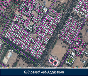
GIS Based Software Development
- Generation of comprehensive GIS/MIS database integrating engineering and land information
- Creation of seamless drawings / route maps with overlays for alignment sheets, stratification, corrosion survey, land information, and crossing details
- Database for disaster management and upgradation of same to facilitate operation and maintenance
- Development of ROU Software – this is a customised Web Enabled GIS based software for Right of Use/Way property management and administration of this Complex Process which have included the compilation and data management more than 10,000,000 parcels compiled by SECON as of date
- Development of Fully Automated Auto Cad based Alignment Sheet generators for Survey, Engineering, Construction and As-Built Alignment Sheets.
- Development of GIS based software to manage Pipeline Construction
- Development of GIS based Pipeline Asset Management Software to monitor Pipeline Right of Way, Integrity and Operation and Maintenance, including Disaster Planning and Management
Engineering for Raw Water Transportation
- Sourcing and Transportation of raw water
- Hydrotesting and Quality tests
- Water for firefighting Reservoir / Tanks at stations
Pipeline Engineering Design
- SECON has associations with renowned Pipeline Engineering companies for Pipeline Engineering Design services.
Pre-construction Assistance
- Identification of validation of pipeline routes
- Assistance in opening of ROU
- Survey and updating of final changes in alignment
- Staking of ROU boundaries and trench centerline
Construction Phase
- Supervision of construction activities
- Project Monitoring and Quality Control
- Maintaining and updating pipe book in line with progress
- Certification of invoices / claims submitted by agencies
- Approval of sub-contractors for various disciplines of works
- Preparation / certification of as-built drawings.
City Gas Distribution Network
- Preparation of Base map of the City from Satellite Imagery
- Preliminary Reconnaissance survey
- Assessment of Consumer requirement
- Detailed Engineering Pipeline Route Survey & Geo-technical Investigation
- Detection of Underground Utilities and Pipelines
- Obtaining Statutory Clearances
- Investigations for City Gate Station (CGS)/ CNG Station
- Acquisition of Land for City Gate Station
- EIA/EMP Study, Risk Assessment and Disaster Management Study including clearances from State Pollution Control Board & Ministry of Environment & Forests, New Delhi
- Generation of GIS database and GIS Based Software Development for the network
Major Projects
Pipeline Projects
- Desktop Study and Reconnaissance Survey, Centerline and Detailed Engineering Route Survey, Soil Stratification & Classification Survey, Soil Resistivity Survey, Population Density Index Survey & U/G Utility Survey Preparation of crossing permission database Cadastral Survey for Palanpur - Jaipur Pipeline Project.- Gujarat State Petronet Limited
- Detailed Engineering Route Survey, Population Density Index Survey & Underground Utility Survey, Soil Stratification & Soil Resistivity Survey, Preparation of database for preparation of Crossing Permission proposal, Cadastral Survey for RoU Acquisition as per P&MP Act, 1962 for Jaipur - Bhatinda Pipeline Project - Gujarat State Petronet Limited
- Reconnaissance Survey, Detailed Engineering Survey, Soil Investigation, Corrosion Survey, Cadastral Survey, Development of GIS / LIS for proposed pipeline from Bawana Tap off point to Nangal for a length of 525 Km - GAIL (India) Limited
- Detailed Route Survey of Proposed Pipeline parallel to Bajhera - Agra - Ferozabad Pipeline - GAIL (India) Limited
- Consultancy work for Reconnaissance Survey, Detailed Engineering Survey, Survey for individual crossings, RoU acquisition as per GW & GP/P & MP Act and obtaining crossing permissions for extension/expansions of proposed PNG network for Valsad GA as per planing 2015-16 for GSPC GAS Company Ltd.
- Consultancy work for support services for opening of RoU, disbursement of RoU Compensation and liaisoning & maintaining public relationship with all govt./concerned authorities for Kothariya spurline network project in Rajkot GA for GSPC GAS Company Ltd.
- Consultancy Services for Reconnaissance Survey and Detail Engineering Survey works for Pipeline Connectivity to Jhagadiya-Kharchi
- Reconnaissance survey work of Anjar-Chotilla Pipeline - GSPL
- Reconnaissance Survey from Dahod to Gujarat / Madhya Pradesh Boarder for Gujarat State Petronet Limited (GSPL)
- Recconnaissance Survey, Cadastral Survey along corridor and at Well pads for Cairn Energy India PTY Limited
- Detailed Route Survey for pipeline enroute along Rewari to Kanpur Phase 1 - HPCL
- Detailed Route Survey for pipeline enroute along Rewari to Kanpur Phase 2 - HPCL
- Route Survey for the proposed product pipelines from Oil Jetty at New Mangalore Port Trust to HPCL MAPOL terminal-Mangalore - HPCL
- Hiring services for Reconnaissance and Detailed Pipeline Route Survey of proposed as well as existing Gas pipeline in OIL's Upper Assam Field - OIL India Ltd
- ROU Acquisition & Detailed Route survey for Slurry pipeline from Noamundi to Jamshedpur - TaTa Steel Ltd.
- Detailed Engineering Survey, Soil Survey, Cadastral Survey & providing services for establishing ROU in ROW of Paradip - Haldia - Durgapur LPG Pipeline Project
- Rou Acquisition and Detailed route Survey for Slurry pipeline from Noamundi to Jamshedpur
- 460 km long Detailed Route Survey, ROU Aqcuisition & Crossing Approvals for Petroleum product pipeline for Rewari - Kanpur Pipeline project
- Hiring of services for Reconnaissance and Detailed Pipeline Route Survey of proposed as well as existing Gas pipeline in OIL's Upper Assam Field
- Hydrological Study, Engineering Survey, Investigation, Preliminary Design of intake system and Raw Water Pipeline, preparation of detail design report & preparation of detailed tender documents
- Detailed Route Survey and Obtaining Permission for laying of pipeline
- Engineering Survey, Investigation, Preparation of Layout Drawing and Technical Specification for Barrage, Intake System and Raw Water Pipeline for Raw water pipeline system for Cement Plant near Gulbarga, Karnataka.
618 km long Hazira-Dabhol pipeline
- Pipeline traverses through highly controversial & disturbed belt of Hazira-Dabhol with heavily built-up areas of Mumbai & Western Ghats (dense forests with large creeks & water bodies)
- Comprehensive Services - Reccee & center line survey, related investigations, cadastral survey, data generation for ROU acquisition, assisting CA for 3(1) & 6(1) publication, serving notices & payment of compensation
- Other Services - Permitting & clearance from various statutory authorities, road, rail lines, foreign pipelines, underground and over ground utilities, coastal and defence lands
1,800 km long pipeline project
- Time critical job consisting re-route survey, field data capture to prepare ‘As-Built’ drawing & documentation
800 km long Myanmar-Bangladesh-India trans-national pipeline
- Difficult North-East hilly terrain, and threat of constant terrorist activity
1,006 km long Mundra-Bathinda Crude Oil Pipeline
- Challenging assignment through Rann of Kutch & Thar desert
2,090 km long Gas Pipeline to Goa-Hyderabad-Kakinada, Bangalore-Chennai-Ongole, Chakan-Uran-Dabhol, Jamnagar-Rewari-1100 km
- Latest tools and software used to capture, download and process data
- Seamless drawings for route maps, alignment sheets, crossing details, stratification, cadastral survey & ROU acquisition on GIS platform
- Best industry practices adopted using satellite imagery, DGPS & Total Stations
- In-house software such as SeconMap, ROU Master & PDMS (Pipeline Database Management System) used for documentation, presentation and retrieval of data
1,320 km long Kochi-Kayakulam-Bangalore, Bangalore-Mangalore-Coimbatore Pipeline
- Pipeline traverses in extremely difficult terrain of Western Ghats and Dimbam forests of Tamil Nadu and densely populated Kerala State
410 km long Jullandhar–Jammu-Pathankot pipeline
- Logistically difficult terrain to work under constant terrorist threat
- Hazira-Loni and HBJ gas pipelines - (3,000 km)
Bailadila-Visakhapatnam, Londa-Ponda Iron Ore slurry pipeline - (400 km)
- Pipeline traverses through extremely difficult, highly undulating tribal belts of Central India and East-Coast with marked variations in ground profile
1,200 km long pipeline distribution network
- Comprehensive survey, investigation, ROU Acquisition, Way Leave License and permitting services for Talasari – Hazira, Dahej – Baroda and Saurashtra pipeline distribution network 1200 km
2,800 km long pipeline survey
- Pipeline survey and investigation for cross-country pipelines including J&K – 2800 km
Topographical Survey to Maninagar DRS Area
- Topographical survey for Maninagar DRS Area related to proposed Ahmedabad city gas distribution network
350km Kota-Jaipur- Rewari- Recconaisance
- Recconaissance Survey
Detailed Route Survey from Kota to Jodhpur
- Detailed route survey of (Part E & Part G of HBJ Upgradation Project Phase - III Gadepan to Nayan gaon - 526 km length + GIS & LIS module for part G)
600km Pipeline survey from Vadinar to Ratlam
- Detailed Route Survey
- Geotechnical Investigations
- Hydrographic Survey along with Cadastral Survey
Pipeline survey – Koyali – Sidhpur – Sanganer
- Detailed route survey
- Cadastral survey
- Obtaining approvals
- ROU acquisition
Land acquisition to Kota Rewari project
- Detailed route survey
- Cadastral survey
- Geotechnical Investigations
440 Km Numaligarh – Guwahati – Siliguri Pipeline Project
- Running Parallel to existing pipeline & conjested developed areas in Assam & West Bengal
- 130 Km Recce and Detailed Route Survey report for Onshore Oil Field Development facilities for CEIL
- 260 Km Pipeline to Industrial Area for the distribution of Gas to potential consumers in state of Madhya Pradesh
Other Major Projects
City Gas Projects
- Procurement and Processing of High Resolution Satellite Images, establishment of Ground Control using DGPS, Preparation of GIS Base Map, GIS Database development and Development of Web based solution Pipeline Information Management System to manage City Gas distribution Network for 10 cities across Gujarat.
- Procurement and Processing of High Resolution Satellite Images, establishment of Ground Control using DGPS, Preparation of GIS Base Map, GIS database development and Development of Web based solution Pipeline Information Management System to manage City Gas distribution Network for 02 cities across Gujarat.
- Preparation of up-to-date GIS Base Map using High Resolution Satellite Image (0.6 m) and Development of Web based GIS Application / Database for planning City Gas Distribution Network for Bhavnagar & Kachchh Districts in Gujarat
- Procurement of Satellite Image, Processing of Satellite Imagery, Preparation of GIS Base Map and Development of Web based GIS Application / Database using Satellite Image to Support Viewing of Gas Network Details, other Utility Networks, Consumer Details, Emergency Assisting Details, Engineering, HSE, O&M, Marketing and Document Management System, etc for Mehsana, Sabarkantha & Gandhinagar Districts in the state of Gujarat
- Route Survey and Allied Works for City Gas Distribution project at Bengaluru for GAIL Gas Limited, Noida
Pipeline Projects
- Bina-Jhansi-Kanpur, Bombay-Manmad, Cochin-Coimbatore-Karur pipeline - (950 km) Major River crossing survey and investigation for Manmad-Indore and Cochin-Coimbatore-Karur pipeline - (180 km).
- Rapar Gadali-Oman India pipeline - (165 km)
- Dabhol-Hazira, Dabhol-Gokak-Goa Spur Line – (938 km) ROU acquisition, way leave licence and permitting services
- Bailadila-Visakhapatnam, Londa-Ponda slurry pipeline - (400 km)
- Mangalore-Bangalore and Hassan-Coimbatore LPG Pipeline - (650 km) Dahej-Vemar-Bijaipur pipeline - (612 km)
- Goa-Kolhapur-Solapur-Hyderabad pipeline - (680 km)
- Kakinada–Hyderabad–Uran Pipeline Phase I & II – (950 km)
- Comprehensive survey, investigation, ROU acquisition, way leave licence and permitting services for talasiar–Hazira, Dahej–Baroda and Saurashtra pipeline distribution network - (1,200 km)
- Goa-Kolhapur-Solapur-Hyderabad pipeline - (680 km)
- Pipeline survey and investigation for cross country pipelines – (2,800 km)
- Pipeline survey, investigation and ROU acquisition, etc. for cross country pipelines - (4,000 km)
- Raw water transportation and effluent disposal - (200 km) Detail engineering for sourcing, storage, make up water and distribution
- Baroda-Ratlam product pipeline – (340 km)
- Hydrocarbon pipeline from MPT to Zuari Nagar.
- Medhkar to IPCL Pipeline
- Hazira–Mora Pipeline