Scope of Work
UNDERGROUND UTILITY DETECTION AND NON DESTRUCTIVE TESTING (NDT)
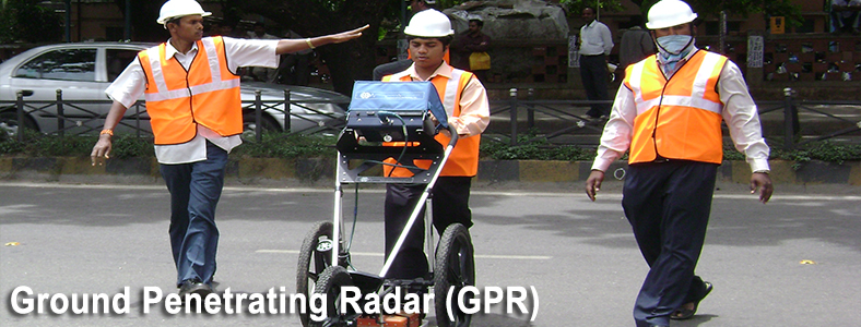
Ground Penetrating Radar (GPR) is one of the latest available Geophysical techniques used for exploring the sub-surface to determine & validate the presence of underground utilities subject to soil conditions
This technique is ideally suited for RECONFIRMING the presence of any buried underground utilities. Using various antenna options available, the equipment is capable of carrying out utility scan, road scan, bridge scan, profiling and structure scan.
Detection and Interpretation of Buried Utilities, Water, Sewerage, Electrical and Optical Cables also be used for soil stratification including delineation of rock profile upto shallow depth
Pipe Locator for buried Pipeline and carrying out non destructive testing(NDT)
Major Projects
Government of Kerala, Kochi Road Fund Board
- Improvement of Kochi Roads, Road Geometrics, Traffic Survey and Utility shifting plans using GPR as part of Detailed Project Report (DPR)
Larsen and Toubro Limited
- Establishment of High Precision Control, Topographical Survey & Underground utility studies including Runway at Chattrapati Shivaji International Airport, Mumbai- 03 locations in grids of 25m
Madhava Hytech-ECCI(JV)
- Detection of buried utilities for purpose of sub grade separator at BHEL and Indian institute of Science (Prof. C.N.R.Rao circle) junction on Sir C.V. Raman Road, Bangalore in grids of 5m
Bharat Electronics Limited
- Detection of underground utilities for exploring a suitable corridor for laying of control cables for the traffic signals at Mosque Road & M.M. Road Junction – Frazer Town, Bangalore
BWSSB
- Detection of underground utilities for laying of pipes at Jakkasandra Circle, Bangalore by GPR
Bruhat Bengaluru Mahangara Palike
- Detection of buried utilities for purpose of construction of under-passes at 21 Junctions in Bangalore City
ABB
- GPR survey for BMRCL Phase 1 - Project - Cable route identification Hoody To Byappanahalli RSS
- Subramanyapura & Puttenahally RSS , 2nd Phase
- V Valley GSS To Mysore Road BMRCL RSS
Brigade Enterprises Ltd
- Carrying out GPR survey for detection of buried underground utilities for proposed construction of Underpass connecting Dr. Rajkumar Road to Tumkur Road
MEGA COMPANY LTD
- Detection of utilities along the proposed alignment of the METRO from Sarkhej to Wadaj ( 12.7 Km )
Central Projects Organisation
- ITC TOWER - INFOTECH PARK
Bangalore Metro Rail Corporation (BMRCL),
- Ground Penetration Radar Survey for Mapping of Underground Utilities at every Pier location from Nayandahalli Station to Kengeri Terminal Station of R-2 Extension in Phase-2.
Nuclear Fuel Complex ( NFC )- Power Distribution Division
- GPR survey for locating utility & Cable Systems at NFC
ERM INDIA PVT LTD
- GPR Survey at Yelahanka site, Bangalore
BOSCH Limited
- GPR Mapping of UG Utilities-MLCP - BAN 604
- GPR Survey for Underpass ( Link Road )
- GPR Mapping of UG Utilities- BAN 601 / 602
For road widening works at Kochi for Kerala Road Fund Board (KRFB)
For GIS mapping at Chatrapathi Shivaji International Airport at Mumbai – Mumbai International Airport Limited through EPC contractor L&T
For Madhava Hytech - ECCI JV for proposed Sub-grade separator at Prof. C.N.R. Rao Circle at Bangalore.