
Scope of Work
SECON SPECIALIZES IN PROVIDING FULL SERVICE GIS SOLUTIONS THAT INCLUDE:
- Field Data Capture,
- Data Processing,
- Database Development
- Database Maintenance
- Data Conversion
- Application Development

SECON’S DOMAIN EXPERTISE INCLUDES:
- Cross country Pipelines,
- Water & Sewer networks,
- Gas distribution networks,
- Electric networks,
- Irrigation networks,
- Transportation networks
- Telecom Networks
- Facility Mapping
- Cadastral/Parcel and Land Use Mapping
- Townships and Industrial Layout planning and mapping
- Digital Terrain Modeling
Major Projects
NATIONAL
GUJARAT STATE LANDUSE MAP GENERATION FROM SATELLITE IMAGERY
The area covered was about 250,000 sq km. Satellite imagery was extensively used for creating the Base Map followed by rapid field verification and surveys. The project was to identify potential user industries for gas and oil products and their location. Customized mapping was done for generation of industrial Base Map, Planning and distribution of pipeline network for supply of gas to the industries.
BASE MAPS PREPARATION AND RECONNAISSANCE SURVEY FOR CITY GAS GRID
- Reconnaissance survey and Detailed Feasibility Report for CNG through City Gas Distribution Network and Preparation of base maps of 1:20,000 using Satellite Imagery, Development Plans, Available maps and Onsite verification for the following cities: Patna, Pune & Varanasi
- Feasibility studies, route finalization and reconnaissance surveys for the City Gas Distribution Networks and Preparation of base maps of 1:75,000 for GAIL using Satellite Imagery, Development Plans, Available maps and Onsite verification for the following cities: Vadodara & Ahmedabad, Gujarat
- Reconnaissance, detailed survey of trunk lines including preparation of base maps for Bombay Gas Grid System
LARGE GAS GRID NETWORKS
GSPL Cross Country Natural Gas Grid Pipeline Network
SECON has executed Natural Gas Grid Pipeline Network project for the development of transportation network for Gas and other Hydrocarbon Products. The total network length is more than 6000 km. SECON conducted survey and GIS data conversion for over 3400 km. The project-involved creation of:
- GIS database for cross-country pipelines consisting of land information, pipeline routes, crossing details, corridor details etc.,
- Satellite image based feature updation
- GPS co-ordinates based seamless data integration
- GIS tools were provided for disaster management, LIS, O&M, effective management of data & documents.
RELIANCE GAS GRID NETWORK
Reconnaissance and Route survey of the proposed Gas Grid Network of Reliance through the developed areas of Kakinada in Coastal Andhra Pradesh. Satellite Imageries were used for the planning and generation of digital landbase.
UTTAR PRADESH WATER SECTOR RESTRUCTURING PROJECT - UPWSRP
A world bank aided project for efficient water management in the Indian state of Uttar Pradesh. The project involved cadastral mapping & GIS based rehabilitation and modernization of irrigation networks covering 615658 Ha having 2.5 million land parcels.
TOPOGRAPHICAL SURVEY - ITPL
Preparation of Topographical map for ITPL Whitefield Bangalore, an IT hub of India.
BANGALORE INTERNATIONAL AIRPORT - DEVANAHALLI
Preparation of Base map using satellite imagery covering 20Km radius and Topographical Survey for around 1790 Hectares including Runway, Taxiway, Apron area, prominent Cargo area etc. for the Bangalore International Airport.
TOWN PLANNING – VIZAG NAVAL BASE
Preparation of town planning map for the Vizag naval base Vishakapatnam.
MUMBAI INTERNATIONAL AIRPORT - MIAL
Preparation of Topographical map / DTM for Chhatrapati Shivaji International Airport Mumbai for 525 hectares and subsurface survey maps for 402.77 Hectares using the Ground Penetrating Radar (GPR).
CAIRN ENERGY
Engineering Property Surveys of well pads, pipeline corridor, approach roads area and generation of cadastral survey data for land acquisition, covering approximately 438 acres for Bhagyam, Shakti & Aishwariya oil fields in the state of Rajasthan.
ROAD TUNNEL PROJECT– SHIMLA
Preparation of Route maps, Topographical maps, Longitudinal Sections & Cross sections etc., for the Road Tunnel Design at Shimla and other parts of Himachal Pradesh.
BANGALORE METROPOLITAN REGIONAL DEVELOPMENT AUTHORITY - BMRDA
Preparation of Topographical map for proposed road network STRR, IRR & RR and eight satellite towns, Bangalore.
UPOR
Urban Properties ownership records for Mysore. Involved digitalize the Land records for Mysore District, Karnataka, India by implementing a special coding system, through which Automated Re-generation of property data was made possible
SURVEY USING TOTAL STATION AND MAPPING OF HASSAN
The detailed survey of topographical features and boundary details of properties using Total Station was carried and topographical maps prepared in digital form, at basic scales 1:500 and derived maps at 1:1,000, 1:20,000 with cadastral details for properties in the Local Planning Area (LPA) of Hassan. The area for survey and mapping was about 100 sq km, which included developed and undeveloped area.
GEO-DATABASE CREATION FOR ROUND TRIP ROAD DISTANCE VERIFICATION IN KARNATAKA
The road survey for the entire state of Karnataka was carried out to identify all weather motorable and the shortest routes for the movement IOCL vehicles (tankers) between its Terminals (2 No.s)/ depots (6 No.s) and the retail/consumer outlets (2241 No.s) to optimize IOCL resources
INTERNATIONAL
BELL SMART DRAWING PROJECT
Using AutoCAD, approximately 1005 central office (CO) equipment “drawings” were reviewed, updated and processed for consolidation into composite floor-level drawing files. Excel spreadsheets were populated with floor space equipment attribute information that were derived from the Smart Block library provided by Bell Canada.
CENTRAL BANK OF LIBYA
An architectural drafting project to convert 270 design drawings into digital format with exact dimensioning.
WATER PROJECT - TOPOGRAPHICAL SURVEY - LIBYA
Design and implementation of Water supply and sanitation system for 119 settlements in Libya spread over an area of 1.7 million sq km covering 27000 hectares of land. The survey drawings were prepared using satellite imagery. The survey details, MP1000 details, Satellite imagery details were superimposed over Ortho rectified satellite imagery in different layers for better understanding of the drawing. This plan was used as the basis for the road LS/CS generation, design of proposed roads and utilities like water, sewage, storm water etc.
CITY OF CHINO HILLS WATER & SEWERAGE PROJECT
Converted the Chino Hills engineering drawings from hard copy to digital Tiff’s format and developed a ESRI Geo-database to store features related to water and sewer. Features to be converted include Water lines, Water valves, Sewer lines, Sewer manholes, Water fittings and Sewer cleanouts.
WATER AND SEWER NETWORK - ORANGE COUNTY UTILITY
Geo-referencing of Orange county’s Water and Sewer network. The project involved preparation of 50000 AS-BUILT sheets and creation of 7000 Project polygons for the data
AS-BUILT GIS PREPARATION OF PIPELINE, STATION AND IT’S ASSOCIATED OBJECTS. (QATAR)
The scope of the project was to transfer the as-built digital data of different systems like Pipeline (3d), Station Piping (3d), Electrical, Instrumentation, Telecommunication, Cathodic protection and Fire & Gas into a GIS compatible format according to client's standard
MAPBOOK CREATION (LA-MESA)
The project involved preparation of Address Map book at 1 inch : 200 feet scale involving creation of feature linked annotations like Street name, Address Range, PedMeter using input parcel, centerlines, City limit boundary as base data.
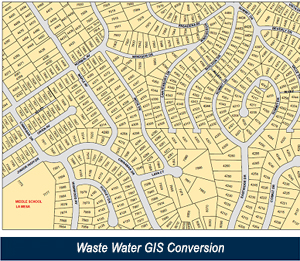
WASTE WATER GIS CONVERSION AND CREATION OF MAP BOOK (COUNTY OF SAN DEIGO)
The project involved conversion and Map book preparation for 455 miles of waste water facilities. This was done by geo-referencing 4296 sheets of as-built engineering drawings. The areas covered were Alpine, Lakeside, Spring Valley, Winter Gardens, Pine Valley, Julian and Campo of San Diego County.
POWER LINE PLAN AND PROFILE PREPARATION (CANADA)
The project involved generation of continuous plan & profile and sheet preparation for 199 km of power line using LiDAR Data.
COMPUTER CADASTRAL CARTOGRAPHY
Each City area is cartographically divided into cadastral maps that usually correspond to the administrative areas of the city. The project involved conversion of City maps of Italy available in hardcopy to a GIS platform. Digitizations of map sheets were carried out using the "Matrice" and updating it with the "Copione di visura".