Key Features
User friendly interface
Provision to query, view and modify design and existing details of canals and 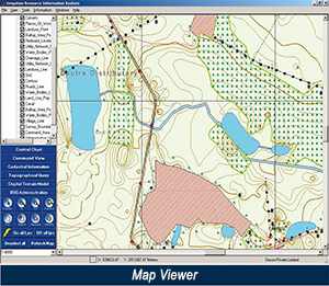 irrigational structures
View comprehensive details of command area
Easy availability of GPS Benchmarks, Cadastral Information, Topographic details like Control Points, Landuse Points, and Culverts
Query and view sensitive areas like Temples, Schools, Hospitals, and Burial grounds
- Observe communication network details such as Transportation, Telephone lines and power lines
- Query and view cadastral details like area of a selected survey number and its Khatauni details (details related to land and village)
- Select and view total area of selected multiple survey numbers
- Easy availability of Elevation data using DTM
- View related documents and photos from a single interface
- Secured data access
Advantages
- IRIS is specially designed keeping in mind the continues requirement of engineers at various levels in irrigation department to manage significant and voluminous data with minimal training.
Testimonial
"We are very satisfied with the services rendered by SECON Pvt. Ltd., and would strongly recommend them for GIS services and software solutions"
Mohd Ahsan, MIS Expert, PACT, UP Water Sector Restructuring Project, Irrigation Dept, UP