Scope of Work
SECON HAS OVER 3 DECADES OF EXPERIENCE IN PROPERTY AND CADASTRAL MAPPING WITH DIVERSE TECHNOLOGIES
- Ground Survey Method
- Satellite Images
- Aerial Photography
SECON also has experience in establishing GIS Based Web Enabled Land Information Systems for Revenue and Land Records Departments for Agencies that manage Property Records.
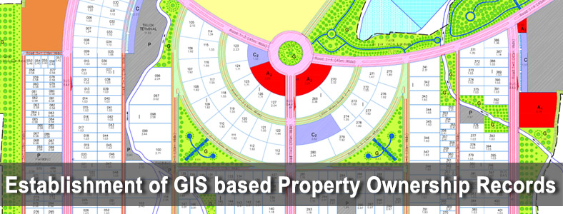
Benefits of GIS based Property Ownership/Cadastral Records
- Just as there is a Unique Identification (UID) for Individuals, there should also be a UID for Properties, since this is a Permanent and Valuable Asset.
- Proper documentation of Land Ownership will avoid the issues of fraud and duplicate ownership in Property related Transactions.
- This also greatly enhances the revenue of the Government since all Properties are mapped and recorded. Tax defaulters can easily be identified.
- This helps the Government detect encroachments on Government Land.
- All of this information is managed in a Digital Database and Customized Maps and GIS software can be created to rapidly and accurately distribute this information to the Public and Government Authorities.
Urban Area Cadastral Mapping
- In Urban Areas, land is very costly and so the tolerances should be <10cm per property corner. Extensive Ground Validation and Verification is required for Urban Area Surveys.
- The requirements for Urban Area Survey can only be achieved by Ground Survey
Major Projects
Resurvey for Banaskantha District, Gujarat State, India
- Client : Settlement Commissioner & Director of Land Records(SC&DILR)
- Area : 10389.82 Sq. Km
- Number of Villages : 1239 (in 12 Taluka)
- Number of Land parcels / properties : 4,47,218
Resurvey for Mahesana District, Gujarat State, India
- Client : Settlement Commissioner & Director of Land Records(SC&DILR)
- Area : 4475.61 Sq. Km
- Number of Villages : 606 (in 9 Taluka)
- Number of Land parcels / properties : 3,57,072
Survey of Hassan City using Total Station and Preparation of Maps for 100 Sq. Km - Govt. of Karnataka, Department of Town & Country Planning
Service Provider under the Urban Property Ownership Record Project for Mysore city - Govt. of Karnataka Survey, Settlement & Land Records - SSLR
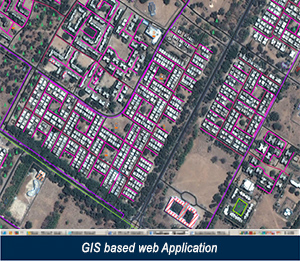
Karnataka Government Urban Property Ownership Records (UPOR) Project
- The Karnataka Government has launched a Pioneering Project to create the Urban Property Ownership Records (UPOR) of the cities of Karnataka. This is one of the first programs of this kind in India.
- The Karnataka Government intends to issue a Property Record Card (PR Card) for Each Property in all its Cities.
- This PR Card will be the only authentic identifying document for the property owned and only this identification will be accepted for Property transactions, securing bank loans etc., once this project is completed.
- As a pilot, 5 of the largest cities after Bangalore are being surveyed to create the UPOR.
- This database is then put into a GIS and the information is distributed to the Citizens at various service centers in the City.
UPOR for Mysore City
- TThe Government of Karnataka has tied up with SECON on a PPP basis for undertaking the Survey and Property Measurement, Data Collection and Database Creation for Mysore City.
- The Department of Survey, Settlement and Land Records (SS & LR) envisaged the urgent need of updated Urban Property Ownership Records for Preparing, Maintaining and preserving Spatial and Non-spatial data relating to Ownership of Properties in the urban area of Mysore City.
- The project for Mysore City is almost complete and will be the first project to be completed under this Program. The project is inaugurated and issue of PR Card commenced by end Nov 2011. This project for Mysore City caters to a population of over 10,00,000 with over 2,75,000 properties in an area of around 200 Sq Kms.
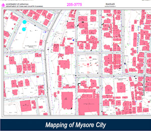
The Accuracy / Tolerance is <10 cm for each Property Corner and the Map Scale is 1:1000.
The Area Covered was:
- The area of coverage of the Mysore Municipal Corporation
- Layouts formed by the Urban Development Agencies even if such layouts are outside the Municipal Corporation limits.
- An additional area equivalent to 20% of the area of the municipal corporation to cover adjacent villages to the Municipal Corporation where significant urbanization has taken place. 42 villages were covered in the Area of Interest.
SECON has also established a Citizen Facilitation Centre (CFC), which will be operational for the entire duration till property records are created.
Brief Scope of Work
- • First time Creation of Property Ownership Records, by Survey, Mapping and Enquiry. Generation of Maps and Sketches of each Property along with Ownership and other Land related details incorporated in a GIS Database.
- Maintenance of the records