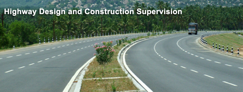
Scope of Work
SECON provides turn-key solutions in the field of Highways using Modern Technology, Remote Sensing, extensive Computer Application for Survey, Planning, Design, Construction Supervision of 4/8 lane Highways, Expressways, Urban Roads, Hill Roads and other Road Networks, related Structures, Bridges, Flyovers including turnkey Land Acquisition assistance.
SURVEY AND INVESTIGATION
- Feasibility Study of Road Corridor, Survey Control, Data capture by Modern Technology, Preliminary and Final Location Survey
- Geotechnical, Material, Pavement and Subgrade Investigations
- Hydraulic and Hydrological Investigations
- Traffic and Social Surveys including Analysis
- Environmental Impact Study, Management and Clearance
- Turnkey Land Acquisition and Computerization of Land Records
DESIGN ENGINEERING AND DETAILED PROJECT REPORT (DPR)
- Compliance to Standards, Code Practices and QAP
- Road Geometrics, Intersections, Alignment Plan, Sections
- Rigid and Flexible Pavement Design
- Design of Structures, Grade Separators, Drainage
- Road Furniture and Safety Features
- Bill of Quantities, Project Costs, Economic and Financial Analysis
- Environmental Management Plan and Resettlement Action Plan
ASSISTANCE IN LAND ACQUISITION, CLEARANCES AND PERMITTING
CONSTRUCTION SUPERVISION
- Project Supervision and Contract Management
- Technical Control, Project Monitoring and Inspection Services
- Quality Control and Certification
- Technical Audit and Quality Audit Services
- Independent Engineering, Claims, Reviews and Arbitration
WEB ENABLED ENTERPRISE GIS DRIVEN SOFTWARE
- Right of Way Property Management
- Comprehensive Construction Project Monitoring for Road and Bridges
- Asset Management
Major Projects
EXPRESSWAYS
Pre-Feasibility Study, optimisation of Road Corridor using Modern Technology, Data Acquisition for Delhi - Jaipur, Delhi - Meerut, Mumbai - Vadodara and Chennai - Bangalore including PDR for Chennai - Bangalore Expressway
4/6 LANE HIGHWAYS
DPR for Nellore - Chilkalurupet, Farukhnagar - Kottakota, Kanyakumari - Trivandrum, Nelamangala - Hassan, Hyderabad – Vijayawada (Malkapuram – Syedmuzhavarpet Section), Jodhpur – Pokaran, Mulbagal – Ranipet, Nelamangala – Tumkur, Bangalore – Mysore, etc.
Intermediate Ring Road, Radial Roads around Bangalore and Techno - Economic Feasibility Study for Satellite Town Ring Roads
2/4 LANE ROADS
Investigations and Design for Sambalpur - Rourkela, Ankola - Bellary, Devanahalli - Kolar, Bangalore - Mysore - Madikeri, K’taka-Maharastra Border to Virajpet, SHs & MDRs in Rajasthan & Jharkhand, etc.
LAND ACQUISITION ON TURNKEY
Mumbai - Vadodara Expressway
URBAN ROADS, FLYOVERS AND INTERNAL ROADS FOR INDUSTRY
Kochi, Kanpur, Bangalore Outer Ring Road, Ranchi Flyover Anjanapura Layout, Bangalore, HPCL Refinery and BASF Mangalore
HIGH ALTITUDE ROADS, DPR FOR DEFENCE PROJECTS
Avalanche Control Structures in Central Himalayas, DPR for Roads and Tunnels at Shimla, Internal Roads for Defence Projects in Andhra Pradesh, Himachal Pradesh and Rajasthan
WEB ENABLED ENTERPRISE GIS
Collation of DPR for 5700 Km of National Highways, development of PMS and BMS for Construction Supervision
CONSTRUCTION SUPERVISION AND PROJECT MANAGEMENT
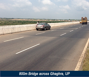
Nellore-Chilakalurupet including 1033 m long Bridge, Krishnagiri-Ranipet, Yadgir-Shahpur, UP State Roads Project (Phase II), PMGSY roads in Vadodara and Anand
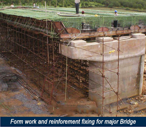
Proof Checking and Supervision for 110 Bridges, Supervision of Operation & Maintenance of 3700 Km Roads in Karnataka
INTERNATIONAL PROJECTS
- Investigations and design for Master Plan Road Network - 1996 km roads (101 towns) in Libya.
- Design of Major bridge over Pulo Sokhrao River on Kabul - Jalalabad Highway section and Structures on Jalalabad Bypass.in Afghanistan to the European Commission
- Design of interchanges for 6 junctions on 2nd Ring Road of Tripoli, Libya.
- Design of Structures, Road and drainage Network for Reservoir and Pumping Stations along Ras Al Zawr, SHUQAIQ Phase 2 and Eastern Province WTS in Saudi Arabia.
- Infrastructure Design for Gargaresh Beach Waterfront, Al Herrah Township, Gharayat City, AL Herrah township in Libya
- Detailed structural Design of Major bridges and interchanges along Second Riyadh Ring Road